Our beloved Route 66,
The "Mother Road" as John Steinbeck
called it ...
... was the most important east to west
thoroughfare carrying the traffic all over the continent from Chicago, IL
to Los Angeles, CA. Travelling the old highway, which was comissioned to be
"US66" from 1926 to 1985, modern roadies will cross 8 states (IL, MO, KS,
OK, TX, NM, AZ, CA) and 3 timezones. Everybody interested in history has to
look out for mile of mile deteriorating, sometimes forgotten roadbeds
beneath desert sand, sagebrush or (that damned) interstate, but there are
also hundreds of contigouos miles still alive and drivable (some of it with
proper equipment only - be careful!).
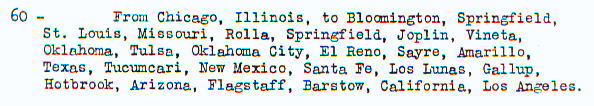 1925 planning of US60 (later US66)
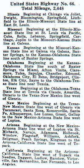 1927 description of US66
During it's lifetime "Mother Road" saw lot of
enhancements, alignment changings, temporary bypasses - and last but not
least the transition of the final 4-lane road into interstate highways.
The information contained in this web is based on 5
years of field studies and lot of work done by courtesy of other route66
afficionates - but there are still question marks about the old right of
ways - some without any answer.
My issue was, to map all the known alignments of
"US66" including it's predessors like "Pontiac Trail" (POT), "Ozark Trail" (OZT),
old "Postal Routes" (OPR), "Santa Fe/Pecos Trail" (SFT), "National Old
Trails" (NOT).
About 80% of the historic US66 is
still existent. Many stretches of what remained are still accessible, most of
it by bike or car (maybe 4 wheel recommended !)
There is lot of contiguous road all along
the original 2448 miles between Chicago and Los Angeles you can drive thru. AZ
claims the sector between Ashfork and Topock as the longest contiguous stretch
of remaining US66 - but that statement is well discussable.
Here are all segments of US66 you can drive
uninterrupted (that means without gaps of more than one mile like
Interstate ramps, short detours etc.) on the Mother Road as it presented itself
not later than in the 1940s. Most of it are from the original 1926 alignment.
Please refer to the atlas and milepost sections for an exact routing.
I only picked up those which have more
than 50 miles.
308 miles
C(h)affeyville,MO to Depew,OK
274 miles Joliet
Road,IL (I-55 Xit269) to East St. Louis,IL
173 miles
Luther,OK to Sayre,OK
164 miles Goffs
Road,CA (I-40 Xit Las Vegas) to W of Daggett,CA
158 miles W of
Ashfork,AZ to Topock,AZ
60 miles
Mesita,NM to Thoreau,NM
60 miles
Devore,CA to Pasadena,CA
56 miles
St. Louis,MO to St. Clair,MO
52 miles
W of Barstow,CA to Hesperia,CA
51 miles
Algodones,NM to Los Lunas,NM